WHAT IS THE PLAN?
The Plan for Prosperity is a transportation and development planning framework that seeks to guide public and private investment in responsible, cost efficient ways to strengthen existing neighborhoods, solidify the area’s economic vitality for lasting benefit, and attract appropriate new development that expands housing and travel choices.
The plan will include an "instruction manual" for local and regional government agencies for shaping land use plans, community design policies, economic development strategies, and infrastructure improvement. It will also serve as a marketing tool that community leaders and citizens can use to attract public and private investors who can help to make the vision a reality.
The plan will include an "instruction manual" for local and regional government agencies for shaping land use plans, community design policies, economic development strategies, and infrastructure improvement. It will also serve as a marketing tool that community leaders and citizens can use to attract public and private investors who can help to make the vision a reality.
PLAN FOUNDATION
Building from the core community values, the following principles supporting the values help form the foundation for the overarching concepts for the Master Plan:
- Healthy, safe, lifelong communities and neighborhoods;
- Community gathering spaces and destinations;
- Diverse economy and job opportunities;
- Multimodal transportation choices;
- Air quality and sustainability;
- Balance neighborhood needs with business and industry;
- Increased educational opportunities; and
- Housing choices and home ownership.
STUDY AREA
|
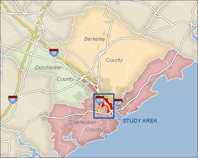
The study area extends from the foot of the Arthur Ravenel, Jr. Bridge (US Highway 17 over the Cooper River) to the Mark Clark Expressway (Interstate 526), including the industrial area on the south side of Charleston International Airport. The area includes a decommissioned Navy base scheduled for redevelopment, diverse neighborhoods, regional shopping, Charleston County and City of North Charleston seats of government, and the site of the expanded Boeing "Dreamliner" facility.
|
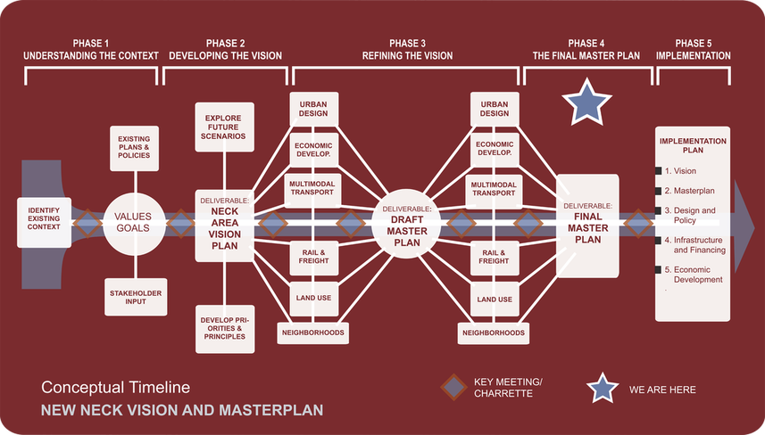
Timeline
The plan is currently in draft form. After a series of formal and informal reviews by participating agencies, organizations and partners, the community will come together in the spring of 2014 to launch the adopted plan.
The entire process has taken about three years. During the spring and summer of 2011, the community developed an overarching vision, principles and goals. In the fall of 2011, a five-day community workshop was hosted. Then, the focus turned toward drafting specific plans, policies and projects to achieve the vision. During 2012, community members and local agencies set priorities, identified resources and crafted an action plan. This whole of information was documented in the Partnership for Prosperity Final Report, which was drafted and presented for review in 2013.
The entire process has taken about three years. During the spring and summer of 2011, the community developed an overarching vision, principles and goals. In the fall of 2011, a five-day community workshop was hosted. Then, the focus turned toward drafting specific plans, policies and projects to achieve the vision. During 2012, community members and local agencies set priorities, identified resources and crafted an action plan. This whole of information was documented in the Partnership for Prosperity Final Report, which was drafted and presented for review in 2013.