
CATALYST AREAS
Development of substantial new mixed use areas, or catalyst areas, represents a major economic opportunity for the Neck area. Simply attracting new construction and investment to the area would create economic benefits, but encouraging economic development and revitalization to take place in a form that connects the local community with an enhanced economy through better accessibility can open up opportunities for creating sustainable long-term prosperity. Both existing residents and new participants alike can benefit from this approach.
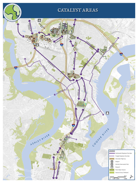
Building from this organization, the Master Plan identifies eight catalyst areas. While some areas may transition to other uses over time, this general layout of districts will help guide catalyst development opportunities as part of an organized system.
THE EIGHT CATALYST AREAS:
South of Mount Pleasant Street catalyst area, located just north of downtown Charleston and the established residential neighborhoods and well-connected grid that surround Hampton Park, is a community gateway. The area should take advantage of the established marketing network of the Charleston Digital Corridor to promote and develop catalyst opportunities along both Meeting Street and Morrison Drive.
North of Mount Pleasant Street catalyst area is a transitional district. While the southern fringe still contains remnants of the grid street network projecting north from downtown, this residential area soon gives way to commercial and light industrial uses. Catalyst opportunities should be oriented towards both residential and public uses to help promote economic opportunity and provide needed community services for the area residents.
Stromboli Corridor catalyst area is a neighborhood center district. Currently, it consists of primarily of large lot industrial uses and container storage areas that separate the Five Mile and Windsor neighborhoods. With this area envisioned as a focal point offering neighborhood services, catalyst opportunities should be oriented towards civic uses such as a community center, workforce training facility, or other public uses to help promote economic opportunity and provide needed services for area residents.
Shipwatch Square catalyst area is a community center. Centered along Rivers Avenue, this area once thrived as a result of growth and military activities at the Charleston Naval Complex and drew people from all parts of the Neck. A mixed use core that includes a grocery store, drug store, and open space can provide much-needed commercial activity and social interaction and help spur other retail and civic uses in the area.
Olde North Charleston catalyst area is a neighborhood center district. This portion of North Charleston was laid out with Park Circle as the center and separate areas designated for residential, commercial and industrial uses. The catalyst area, situated between the residential lots and the growing industrial uses along the Cooper River, developed as the business district. New catalyst development along Montague Avenue can introduce vertical mixed uses to expand housing choices and provide needed goods and services.
Amtrak Station catalyst area is a neighborhood center. Located off Rivers Avenue just north of Durant Avenue, this area is bordered to the north by the Liberty Hill neighborhood; to the east by the Mixson project; and to the west by CSX railroad tracks used by Amtrak’s Silver Meteor service. The area also includes light industrial and commercial uses. Catalyst opportunities include preservation of the Amtrak station, creation of office and community incubator space, and mixed neighborhood uses. There may also be potential to locate the Intermodal Center at this location.
Mall Drive catalyst area is a regional gateway. I-26, a regional roadway that not only serves the Neck peninsula but ties the Charleston area to I-95, bisects the catalyst area and intersects with I-526 directly to the north. Rivers Avenue, Montague Avenue, and International Boulevard, each with exits from either I-26 or I-526, create the framework for this area. With its regional visibility, this area presents an opportunity to become an urban center of the region with offices, retail, residential and related uses.
Convention Center catalyst area is planned to function as a regional gateway. With three exits from I-526 and one exit from I-26, this gateway district is easily accessible from all parts of greater Charleston as well as regional destinations. The Charleston International Airport and Boeing plant are located directly to the north and west and are major economic drivers that influence this catalyst area. The proposed Intermodal Center sets the tone for the entire catalyst area and begins the transformation of this area to a mixed use regional gateway.